For many Indianapolis residents, the local system of greenways has become a favorite staple of our community. It’s encouraging and exciting to think how far the system has come in the 22 years that have past since the Indy Greenways Foundation was formed in 1991. Over the course of the summer, the foundation has traveled around the city to collect ideas and feedback about how the greenways systems should develop from here, and just recently they made their 2013-2023 Master Plan public. The plan is available here.
It’s a comprehensive, 102-page document, and there is a LOT to get excited about.
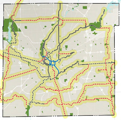
Put simply, the plan contains four parts: 1) Fund and complete the trails that have already been outlined or started; 2) Create new connections to the city’s center; 3) Plan a complete circle of trails that would loop the outer parts of the city to connect community resources and existing trails; 4) Create a system of connectors that utilize corridors of opportunity and provide greenway accessibility in underserved areas.
The PDF is absolutely worth your time – if you’re in a hurry, skip to page 66 of the document, that’s where the recommendations start to come into focus. It’s hard to guess how this plan proceeds in terms of funding and construction, but it’s an exciting plan regardless of the hurdles ahead.
I love the idea of the trail “loop”. This will not only be beneficial to recreational trail users, but to those of us that commute to a job/home that isn’t downtown. Plus, it might help revitalize the townships that have seen some serious blight because of suburban flight.
Here’s a link to the page on the trail loop. I was just getting this image uploaded when I read this comment, because I also love the idea.
Which of these trails conflict with potential commuter rail opportunities?
The only possible segment of the current Indy Connect plan that was going to be rail is Green Line aka the Nickelplate line which does not conflict with any of these plans.
What you are likely referring to is the use of CSX lines going south to Greenwood. This was ruled as untenable because of the volume of freight traffic going down there. Also, there would not be enough right-of-way to add a second set of rails for a dedicated transit line. Bus rapid transit was chosen as the vehicle of choice for all the other lines (Red, Blue, Orange, and Purple).
I might get tarred and feathered for saying this around here, but I would actually support a rail-trail conversion along the Nickel Plate line, vs a transit line. I got to ride the Fair Train for the first time last month (my 2 year old LOVES trains) and man, that line has the potential to be a well used recreational and commuting trail from Fishers to where it joins the Monon NE of downtown.
I doubt you’ll get tarred and feathered for that. I think all the lines should be BRT because of cost and economies of scale (maintaining all buses instead of buses AND a train).
Now, if you were advocating the Nickelplate be turned into a freeway from Fishers, then we might have to ban you for life. 🙂
So I finally got a chance to peruse the pdf of the plan. One thing I did notice is that on page 56, it shows various standards for bike facilities. It DOES NOT show sharrows. If they aren’t included in the standards, they need to stop using them. I suppose one explanation is that since this is the green way plan, that won’t run on streets, so no sharrows would be necessary anyway. However, they do show on-street bike lanes.