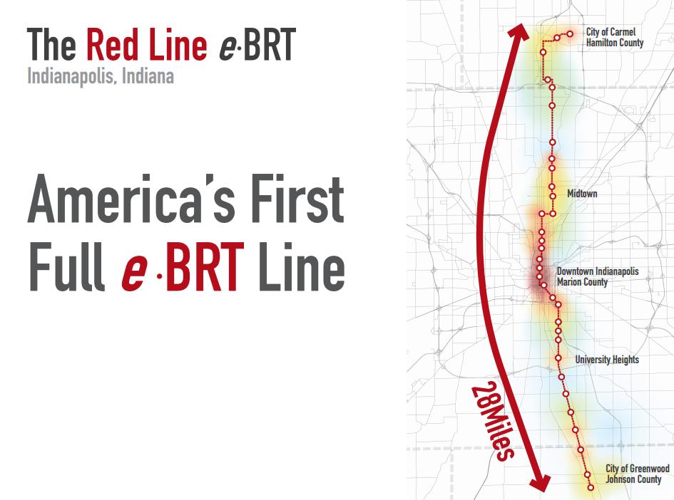
Yesterday, Indy Connect made a big splash on local media with the public announcement of a $2 million dollar grant for engineering along the proposed Red Line from Carmel to Greenwood. Â This post intends to give a quick rundown of the information that we know, as well as provide the public a peek into how the buses will be run. Â First, the links from local media:
Next, a link to the pdf document released from the city. Â Some highlights below:


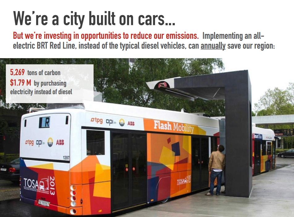
That last image is interesting, because it displays a new technology that has been demonstrated in Switzerland by a firm known as ABB. Indianapolis is planning for these buses to be all-electric, and this new technology is exciting as it eliminates the need for unsightly overhead wires. A video that highlights the benefits is embedded below:
All of this sounds exciting, but it is important to temper expectations a bit. As the Indy Star article mentions, a lot could still get in the way of getting this system from being built. Also, we still don’t know how much of the system will be in dedicated bus lanes, or the buses will still have to compete with auto traffic. However, it’s nice to get excited about the potential. The city’s document gives the public a plan to rally around as we look to finally address our long-standing issues with mass transit.
The one thing I worry about with the red line (or any BRT system) with its less frequent stops is that the distance between stops will be too great for some users and that it may bypass some of our more productive places. Yes, having stops at every block is excessive, but some less mobile people will have difficulty using the red line if they can’t even walk to the nearest major intersection. I also recall at an IndyConnect presentation in the Arts Garden that there was no planned stop at 52nd street. Frankly, that’s ridiculous. We need to make the system as quick as is reasonable, but in order for this thing to make any sort of fiscal sense it first and foremost needs to connect productive places. Our commercial nodes along College are all the places the places where we should see the most value captured from an investment in real transit.
I sorta agree. However, if bus 17 continues to run along College, and we could actually run it every 15 minutes instead of every half an hour, then we could still see more Transit-oriented development along those College Avenue nodes. And we should probably remove some of the stops while we’re at it, including the one that I usually use.
I guess I assumed the 17 would no longer be running, but then we wouldn’t have a service through Broad Ripple and over to Glendale. Maybe it would run in a reduced capacity to just connect Glendale with College & the red line. Agree with you on the 17, though. Frequency needs to be every 15 minutes (and mostly on time…ahem!!) with stops only at the intersections (Kessler -> 57th -> 54th -> 52nd -> 49th etc.)
Great news and it’s encouraging to see our city leaders keeping focus on mass transit. However, some of the marketing is questionable. Yes, there may be more residents and employers on the route than other cities, but all of those cities’ routes are shorter (in some cases much shorter). So it all comes back to density which is the reason mass transit has never made it past the general assembly. Improved mass transit makes sense for the region but I struggle to see why the approach is the same. Why not start with a smaller route and expand as necessary? Old city limits definitely, rest of Marion county probably, Hamilton county maybe, Johnson county probably not.
There is certainly some fluffing up of the statistics going on, so you have a good point there.
You won’t get a ton of argument from me about the length of the route. But, I think getting the suburbs to change a bit of their built form to accommodate transit would still help the region. It all depends on how it is implemented. If they build a ton of park-and-rides, I don’t think it will be all that great of a deal for us.
Nate, there is surprising density around the County Line/Madison/US31 area. Lots of apartments. There is also a lot of shopping as well as a major hospital (Community South), which means jobs.
There’s also another busy node at UofI/Southern Plaza, just inside 465.
Chris, the problem around there is that it might be the most auto dominated place in the entire region. I ride my bike all around town but that is without a doubt the scariest and most unwelcome place I have ridden. I just can’t see anybody walking to get a bus around there.
It would definitely require some significant street/sidewalk changes to make the entire corridor south of I-465 into a place safe for pedestrians (riders). And hopefully some of that happens, but nonetheless, with a BRT, I see good value in extending the line into the suburbs to provide access to areas that IndyGo riders can’t current reach very easily or often. One of the advantages with BRT vs. rail is that it will be much easier to adjust the length of individual bus runs to accommodate demand. I would expect that while all buses will probably run to Carmel (or at least the far north side), probably half of the runs will terminate around UIndy with only limited service to Greenwood.
I agree. However, if the line hits a corner of the Greenwood Park Mall there is surprisingly good pedestrian infrastructure through the parking areas there.
Connecting people to those lower-wage jobs, and doing a “park and ride” to get suburban cars off the highway at peak are both good ridership strategies. Rush hour traffic to and from Greenwood is horrible.
The statistics are more than stretching the truth. The comparisons are more apples to oranges. The red Line is proposed to be 28 miles in length, compared to 7 miles for the Cleveland Health BRT Line, 7.1 miles for Nashville’s Amp BRT Line (proposed), 3.3 miles for Detroit’s M1 Streetcar Line (under construction), 3.6 miles for Cincinnati’s Streetcar Line (under construction), and approximately 9 miles for Grand Rapid’s Silver BRT line (just started service August 25th). Cincinnati’s streetcar line will be a circulator approximately 1.5 miles in length.
Butler is definitely not connected to the Red Line, and IUPUI is only connected via bus transfers.
The employment statistics are dubious at best. The MPO most likely used traffic analysis zones, whose boundaries are far larger than the 1/2 mile Red Line buffer zone.
Any gross assessment comparisons will be skewed because downtown Indianapolis – which has the highest assessed commercial values in the State – is included.
Regarding the walkability on the south side – fortunately this runs on Madison Ave which is more bike / ped friendly than US 31. Lots of sidewalks along Madison and into surrounding neighborhoods. Still not great – but much better than 31.
I used to live in Denver Colorado for 9 months and I think the is a good idea.But more needs to be done in rapid transit in Indianapolis.Denver has light rail that goes all over downtown Denver and out to the suburbs.Denver has a rtd bus shuttle that goes from one side of downtown to the other.Denver has some of the best transportation in the country.I took my disabled bus pass and rode a rtd grey hound type bus from Denver to boulder Colorado for 50 cents.Distance 50 miles one way.This was back in 1995.Indianapolis needs something like this.Indiana is a beautiful state and we need rapid bus lines like the red line to cover whole state.What if we had a red line bus that ran from downtown Indianapolis to Indiana dunes state park in northern Indiana.What about a red line from downtown Indy to Nashville Indiana.The red line should run through all small towns.The red line needs to run to all state parks in the state too.